- Español
- English
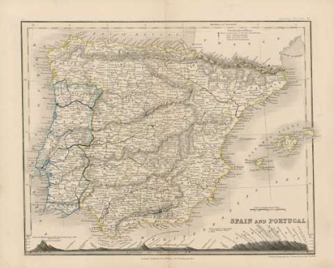
Spain and Portugal


Library: Regional Library of Madrid
Uniform Title: España. Mapas generales. Ca. 1840
Title: Spain and Portugal [Material cartográfico] / Drawn & Engraved by J. Dower Pentonville London
Área de datos: Escala [ca. 1:4.300.000]. 80 English Statute Miles [=3 cm]
Publication: London : Published by William Orr Paternoster Row, [1840?]
Physical description: 1 mapa : grab., col. ; 21 x 25 cm en h. de 25 x 31 cm
Notes: En la parte superior de la hoja, a la derecha, encima del mapa "School Atlas 16", a la izquierda: "XX"
Título en la parte inferior derecha
Márgenes graduados. Dibujados meridianos y paralelos formando cuadrícula. Meridiano de origen: Greenwich. Relieve por normales. Red hidrográfica. Red viaria. Abundante toponimia en inglés con nombres en español y portugués . Perfil costero sombreado. Divisiones administrativas delimitadas en líneas de rayas discontinuas para los países y líneas de puntos para las divisiones provinciales. En la parte superior, abarcando el territorio francés, clasificación de los lugares según el número de habitantes, explicación de la representación simbólica
Fecha de publicación tomada de la obra "Cartografía peninsular", I. Colomer, 1992, p. 186, nº 672, según consta en la BNE, Biblioteca Nacional de España
Contornos de España y Portugal iluminados a la aguada en color amarillo para España y en color azul para Portugal. Divisiones administrativas interiores también diferenciadas por los mismos colores
Incluye en la parte inferior perfil montañoso que atraviesa España desde el "Cerro de Mulhacen" hasta los Pirineos pasando entre otros lugares por Madrid, Escorial, Peñalara, Segovia, Burgos, Vitoria. Se mide desde el nivel del mar en pies ingleses
Subject / place / event: España - Mapas
Portugal - Mapas
Other authors: Dower, John Crane, fl. 1820-1847
Wyld, James, 1790-1836
Orr, William Somerville, m. 1873
Secondary titles: Portugal. Mapas generales. Ca. 1840
Document type:
 Maps
Maps
Copyright:


![]()
© BPCM 2013-2020