- Español
- English
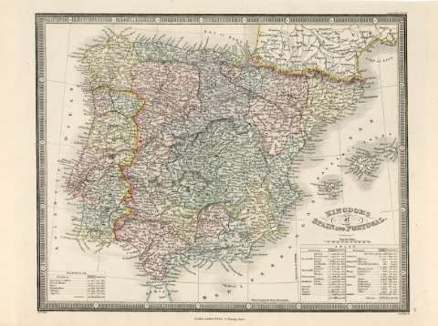
Kingdoms of Spain and Portugal


Library: Regional Library of Madrid
Uniform Title: España. Mapas generales. Ca. 1878
Title: Kingdoms of Spain and Portugal [Material cartográfico] / J .W. del. ; Stockley sc.
Área de datos: Escala [ca. 1:5.400.000]. 100 English Miles [=3,4 cm]
Publication: London : James Wyld, 5 Charing Cross, [1878?]
Physical description: 1 mapa : grab., col. ; 23 x 28 cm en h. de 25 x 35 cm
Notes: En la parte superior derecha de la hoja, encima del mapa: "Atlas of the World", en la parte inferior derecha de la hoja, encima del mapa: "16"
Título en la parte inferior derecha
Márgenes graduados. Dibujados meridianos y paralelos formando cuadrícula. Meridiano de origen: Greenwich. Relieve por normales. Red hidrográfica y de caminos. Red ferroviaria. Toponimia en inglés, con nombres en español y portugués. Abundante toponimia en todo el perfil de la costa. Costas sombreadas. Divisiones administrativas delimitadas por líneas de rayas discontinuas para los países y de puntos para las divisiones provinciales.
Fecha de publicación tomada de la Cartoteca Digital del Institut Cartogràfic de Catalunya: vacani.icc.cat
Divisiones administrativas diferenciadas por color
Ámbito geográfico: Abarca también parte del sur de Francia y muy poco del norte de África
Inserta en el ángulo inferior derecho información sobre la división territorial de España, la extensión en millas de las provincias y su población. En el ángulo inferior izquierdo, aparece los mismos tipos de datos sobre Portugal. En ambas relaciones aparecen indicados los totales en cuanto extensión y población
Subject / place / event: España - Mapas
Portugal - Mapas
Other authors: Wyld, James, 1812-1887
Stockley, S.
Secondary titles: Portugal. Mapas generales. Ca. 1878
Document type:
 Maps
Maps
Copyright:


![]()
© BPCM 2013-2020