- Español
- English
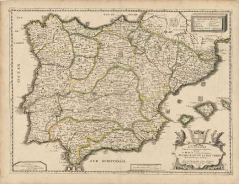
Spanien und Portugal


Library: Regional Library of Madrid
Uniform Title: España. Mapas generales. 1838
Title: Spanien und Portugal [Material cartográfico] / entworfen u. gezeichnet von C. F. Weiland
Área de datos: Escala [ca. 1:2.260.000]. Spanische (Castilische) Leguas zu 5.000 Varas 26,6 auf 1 Grad [=5,5 cm]
Publication: Weimar : Im Verlage des Geógraphischen Institus, 1838
Physical description: 1 mapa : grab., col. ; 50 x 63 cm en h. de 57 x 71 cm
Notes: Título en la parte inferior derecha
Escala expresada también en otras unidades
Relieve por normales y sombreado. Toponimia en español y francés. Ciudades representadas por símbolos según su importancia y número de habitantes. Costas sombreadas
Divisiones administrativas resaltadas e iluminadas a la aguada en colores diferentes
Ámbito geográfico: Abarca también parte de la costa del norte de África
Inserta: pequeño plano de Cádiz y mapa de accesos a Madrid en la parte inferior derecha, mapa de accesos a Lisboa en la parte inferior izquierda y mapa de la bahía de Gibraltar en la parte superior izquierda
Subject / place / event: España - Mapas
Portugal - Mapas
Nombre jerárquico lugar: España - Madrid
Portuga - Lisboa
Other authors: Weiland, Karl Ferdinand, 1782-1847
Document type:
 Maps
Maps
Copyright:


![]()
© BPCM 2013-2020