- Español
- English
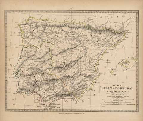
Ancient Spain & Portugal : Hispania or Iberia : [map]


Library: Regional Library of Madrid
Uniform Title: España. Mapas generales. 1838
Title: Ancient Spain & Portugal [Material cartográfico] : Hispania or Iberia : [map] / by Philip Smith. Univ. Coll. London ; J. &. C. Walker, sculpt.
Área de datos: Escala [ca. 2.554.300]. 150 Roman Miles 75-1 Degree [=8,7 cm]
Publication: [London] : Published by the Society for the Diffusion of Useful Knowledge..., 1838
Physical description: 1 mapa : grab., col. ; 29 x 38 cm en h. de 35 x 41 cm
Notes: En el centro del margen superior: "46", correspondiente a la numeración de la obra
Título en el ángulo inferior derecho con datos del autor y publicación
Escala expresada también en: "30 Spanish Leagues 16, 4-1 Degree" ; "30 Portuguese Leagues 18-1 Degree" ; 150 British Miles 69-1 Degree". Aparecen también en el ángulo inferior derecho
Márgenes graduados. Dibujados meridianos y paralelos formando cuadrícula. Relieve por normales. Red hidrográfica. Toponimia en latín. Red viaria. Divisiones administrativas delimitadas por líneas de puntos resaltadas por el color
Aparece bajo los datos del título y el autor: "Published under the Superintendence of the Society for the Diffusion of Useful Knowledge". En el margen inferior: "Published by the Society for the Diffusion of Useful Knowledge Dec[embe]r 1st. 1838"
Divisiones administrativas y la costa diferenciadas por líneas de color iluminadas posteriormente a la aguada, en color verde Lusitania, en color rojo la Bética y en color amarillo verdoso el resto de la Península
Ámbito geográfico: Representación territorial de la totalidad de la Península Ibérica indicando los diferentes pueblos antiguos que la ocupaban
Subject / place / event: España - Historia - Edad antigua, hasta 414 d.C. - Mapas
Portugal - Historia - Edad antigua, hasta 414 d.C. - Mapas
Secondary titles: Portugal. Historia. Edad antigua. (1838)
Document type:
 Maps
Maps
Copyright:


![]()
© BPCM 2013-2020