- Español
- English
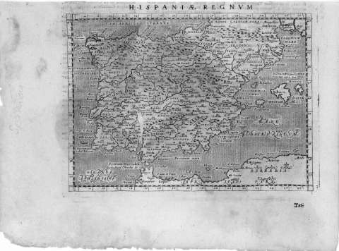
Hispaniae Regnvm


Library: Regional Library of Madrid
Uniform Title: España. Mapas generales. 1713
Title: Hispaniae Regnvm [Material cartográfico] / [Alphonsi Lasor a Varea]
Área de datos: Escala indeterminada
Publication: [Patavii] : [Ex Typographia olim Frambotti, nunc Jo: Baptistae Conzatti...], [1713]
Physical description: 1 mapa : grab. ; 13 x 18 cm en h. de 18 x 25 cm
Notes: Al verso del mapa texto en latín (Bibliografía)
Mapa perteneciente a: "Universus Terrarum Orbis Scriptorum Calamo Delineatus hoc est Auctorum Fere'Omnium... Studio, et Labore Alphonsi Lasor a Varea..." Padua, 1713.
Referencias: Fuente de información: Maps in the Atlases of the British Library , v. 1, p. 643, ref. 241
Márgenes graduados. Dibujados meridianos y paralelos formando cuadrícula. Relieve por montes de perfil. Abundante toponimia en latín y español. Hidrografía. Costas y mares punteados
Datos de área de publicación tomados de la obra anteriormente citada
Ámbito geográfico: Comprende toda la Península Ibérica, la costa norte de África y el sur de Francia
Subject / place / event: España - Mapas
Portugal - Mapas
Document type:
 Maps
Maps
Copyright:


![]()
© BPCM 2013-2020