- Español
- English
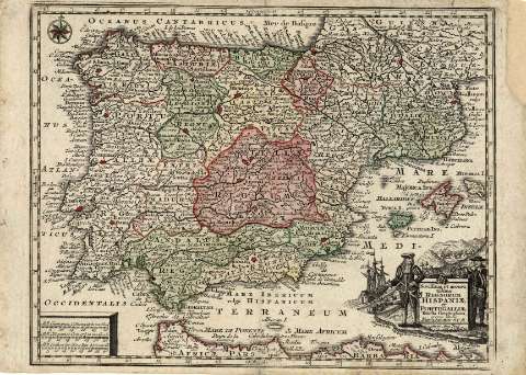
Novissima et accuratissima Regnorum Hispaniae et...


Library: Regional Library of Madrid
Uniform Title: España. Mapas generales. ca. 1750
Title: Novissima et accuratissima Regnorum Hispaniae et Portugalliae tabella geographica [Material cartográfico] / excusa studio Matth. Seutter S.C.M., Geogr. Aug. Vind
Área de datos: Escala [ca. 1:5.800.000]. 30 Mill. Germanica Conmunia 15 in uno Grad. [=3,8 cm]
Publication: In Augsb. : Anjez o un Verlag bey Tob. Conr. Lotter, Geogr., [1750?]
Physical description: 1 mapa : grab., col. ; 20 x 26 cm en h. de 22 x 30 cm
Notes: Referencias: Fuente de información: Hernando, A. El mapa de España, 1995, p .234 y Tooley's dictionary of mapmakers, 1999-2004, v.3, p.158
Escala expresada en otras unidades
Orientado con rosa con lis. Márgenes graduados
Toponimia en latín y español. Red hidrográfica. Relieve por montes de perfil. Costas sombreadas
Divisiones administrativas diferenciadas por líneas de puntos y color
Este mapa se publicó incluido en el Atlas geographicus portatilis , editado por T.C. Lotter entre 1760-1762
Título en cartela rematada por dos coronas, a los lados dos caballeros de la época y paisaje marítimo
Subject / place / event: España - Mapas
Portugal - Mapas
Other authors: Lotter, Tobias Conrad, 1717-1777
Seutter, Matthaeus, 1678-1756
Secondary titles: Portugal. Mapas generales. ca. 1750
Document type:
 Maps
Maps
Copyright:


![]()
© BPCM 2013-2020