- Español
- English
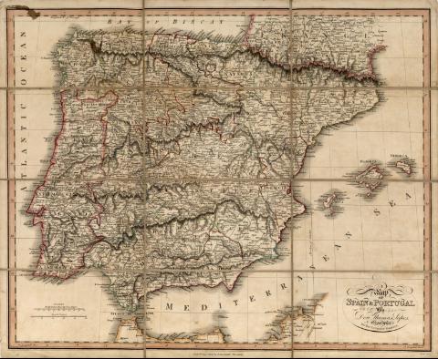
Map of Spain & Portugal


Library: Regional Library of Madrid
Uniform Title: España. Mapas generales. 1808
Title: Map of Spain & Portugal [Material cartográfico] / by Don Thomas Lopes Geographer to His Catholic Majesty ; Neele sculp.
Área de datos: Escala [ca. 1:2.500.000]. 100 British Statute Miles 69 1/2 to a Degree [= 3,1 cm]
Publication: [London] : Pubd. 3d. Sepr. 1808 by I, Stockdale, Piccadilly, 1808
Physical description: 1 mapa : grab., col., montado sobre tela ; 44 x 54 cm en h. de 46 x 56 cm, pleg. en h. de 11 x 19 cm
Notes: Título en el ángulo inferior derecho
Escala expresada también en: "50 Spanish Leagues"
Márgenes graduados. Dibujados meridianos y paralelos formando cuadrícula. Meridiano de origen: Londres. En el ángulo superior izquierdo "Longitude E of Teneriffe". Relieve por normales. Hidrografía. Red viaria. Topónimos en inglés con nombres en español y en portugués. Costas sombreadas por un fino rayado y abundante toponimia. Ciudades representadas por edificios de diferentes tipos según su importancia y característica jurisdiccional. Divisiones territoriales delimitadas por líneas discontinuas y por líneas de puntos
Divisiones territoriales diferenciadas por líneas de color iluminadas a la aguada
Ámbito geográfico: Abarca también parte de la costa norte de África y el sur de Francia
Subject / place / event: España - Mapas
Portugal - Mapas
Other authors: López, Tomás, 1730-1802
Neele, Samuel John, 1758-1824
Stockdale, John, ca. 1749-1814
Secondary titles: Portugal. Mapas generales. 1808
Document type:
 Maps
Maps
Copyright:


![]()
© BPCM 2013-2020