- Español
- English
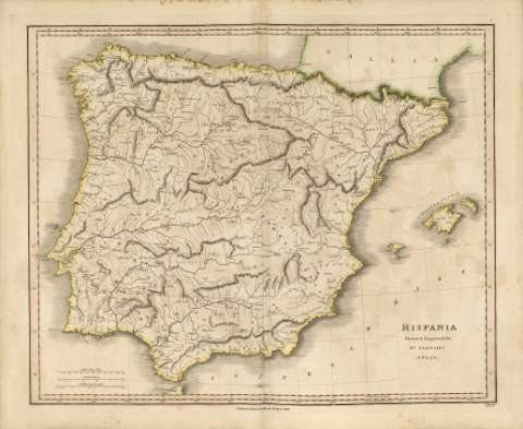
Hispania : Atlas


Library: Regional Library of Madrid
Uniform Title: España. Mapas generales. 1821
Title: Hispania [Material cartográfico] : Atlas / Drawn & Engraved for Dr. Playfair's ; B. Smith sculpt. Walworth.
Área de datos: Escala [ca. 1:2.270.000]. 150 British Statute Miles [= 7,8 cm]
Publication: Edinburgh : Published by Macredie Skelly & Cº., 1821
Physical description: 1 mapa : grab., col. ; 48 x 59 cm en h. de 52 x 63 cm
Notes: Título en el ángulo inferior derecho del mapa
Mapa probablemente perteneciente a: "A New general Atlas Ancient and Modern" de James Playfair
Escala expresada también en: "25 Spanish Leagues" y "40 Castillian Legal Leagues"
Márgenes graduados. En la parte superior e inferior doble margen en relación al Meridiano de Greenwich y a la Longitud Este de la Isla de Hierro. Dibujados meridianos y paralelos formando cuadrícula. Relieve por normales. Red hidrográfica. Escasa toponimia en latín. Costas sombreadas por un fino rayado
Contornos delimitados y resaltados en color amarillo para la Península Ibérica y para las Islas Baleares, en color verde para la Galia y en color rosa para la pequeña parte africana que se observa en el mapa
Ámbito geográfico: Comprende la división de la Península Ibérica en la época romana
Subject / place / event: España - Historia - Epoca romana, 218 a.C.-414 d.C. - Mapas
Portugal - Historia - Epoca romana, 218 a.C.-414 d.C. - Mapas
Secondary titles: Portugal. Mapas generales. 1821
Document type:
 Maps
Maps
Copyright:


![]()
© BPCM 2013-2020