- Español
- English
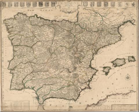
L'Espagne


Library: Regional Library of Madrid
Uniform Title: España. Mapas generales. ca. 1720
Title: L'Espagne [Material cartográfico] / Par N. de Fer Geographe de sa Majesté Catolique ; P. Starck-man sculpsit
Área de datos: Escala [ca. 1:2.137.000]. Vingt Lieües Communes d'Espagne [=5,2 cm]
Publication: A Paris : Chez Danet gendre de l'auteur à la Sphere Royale sur le pont N. Dame, [1720?]
Physical description: 1 mapa : grab., col. ; 49 x 61 cm en h. de 51 x 62 cm
Notes: En el ángulo inferior izquierdo: "Avec Privilege du Roy et Aprobation de Mr. de la Hire de l'Academie Royale des Sciences"
Mapa publicado por Nicolás de Fer en 1716, según un ejemplar conservado en la Biblioteca Nacional (Madrid), y reeditado por Guillaume Danet, su yerno y sucesor entre 1720 y 1732
Escala también expresada en: "Vingt cinq Lieües Communes de France"
Orientado con rosa con lis. Relieve por montes de perfil y sombreado. Hidrografía. Abundante toponimia. Poblaciones representadas por conjuntos de edificaciones según su importancia. Divisiones administrativas delimitadas por líneas de rayas discontinuas. Costas sombreadas
Fecha de publicación basada en los años de actividad de Nicolás de Fer y Guillaume Danet
Divisiones administrativas realzadas por aguada de colores diferentes
Decoración barroca en la parte superior, en donde aparece la cartela del título en el centro, a su derecha escudos de Portugal, Algarve, Galicia, Toledo, Sevilla, Vizcaya, León y Granada. A la izquierda, escudos de Asturias, Castilla, Navarra, Aragón, Valencia, Murcia, Cataluña, Mallorca y Córdoba
Ámbito geográfico: Abarca también Portugal y parte de la costa del norte de África
Inserta en el ángulo inferior izquierdo longitudes y latitudes de los principales lugares de España siguiendo las nuevas observaciones de la Academia Real de las Ciencias, en el derecho, las escalas
Subject / place / event: España - Mapas
Portugal - Mapas
Other authors: Fer, Nicolás de, 1646-1720
Danet, Guillaume, ca. 1670-1732
Starckman, P. (fl. 1705)
Secondary titles: Portugal. Mapas generales. ca. 1720
Document type:
 Maps
Maps
Copyright:


![]()
© BPCM 2013-2020