- Español
- English
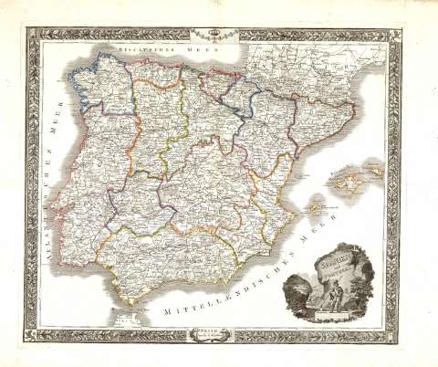
Spanien und Portugal : [Karte]


Library: Regional Library of Madrid
Uniform Title: España. Mapas generales. 1820-1840?
Title: Spanien und Portugal [Material cartográfico] : [Karte]
Área de datos: Escala indeterminada
Publication: Pesth : bey K.A. Hartleben, [1820-1840?]
Physical description: 1 mapa : grab., col. ; 42 x 49 cm en h. de 56 x 81 cm
Notes: Márgenes graduados
Relieve representado por normales
Costas sombreadas
Red hidrográfica y de caminos representada
Abundante toponimia y cultivos representados
Delimitaciones en color
Fecha aproximada tomada del catálogo del librero
Cartela del título en escena paisajística con personaje sobre un pedestal. Alrededor guirnalda floral y en la parte superior Toisón con Corona Real .
Subject / place / event: España - Mapas
Portugal - Mapas
Secondary titles: Portugal. Mapas generales. 1820-1840?
Document type:
 Maps
Maps
Copyright:


![]()
© BPCM 2013-2020