- Español
- English
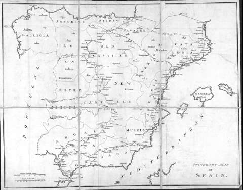
Itinerary Map of Spain


Library: Regional Library of Madrid
Uniform Title: España. 1779. Mapas generales
Title: Itinerary Map of Spain
Área de datos: Scale [ca. 1:2.700.000]. 30 common spanish leagues [=7,2 cm]
Publication: London : printed for P. Elmsly, 1779
Physical description: 1 mapa : grab., montado sobre tela ; 44 x 56 cm, pleg. en 25 x 19 cm
Type of content: Imagen (cartográfica ; fija ; bidimensional ; visual)
Type of media: sin mediación
Notes: Escala expresada también en 100 british statute miles
Incluido en : Travels through Spain in the years 1775 and 1776 .. . / by Henry Swinburne. London : printed for P. Elmsly, 1779
Registros relacionados: En: Travels through Spain in the years 1775 and 1776 in which several monuments of roman and moorish architecture are illustrated by accurate drawings taken of the spot
Subject / place / event: España - Mapas
Document type:
 Maps
Maps
Copyright:


![]()
© BPCM 2013-2020