- Español
- English
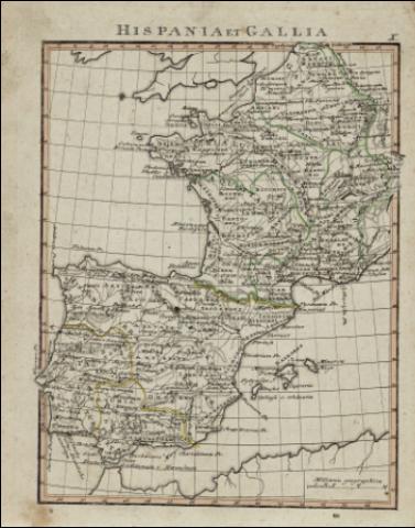
Hispania et Gallia


Library: Regional Library of Madrid
Uniform Title: España. Mapas generales. Ca. 1800
Title: Hispania et Gallia [Material cartográfico] / [Gerhard Ulrich Anton Vieth ; Carl Philipp Funke]
Área de datos: Escala [ca. 1:2.252.250]. 45 Milliaria geographica [=3,7 cm]
Publication: [Weimar?] : [Industrie-Comtoir?], [1800?]
Physical description: 1 mapa : grab., col. ; 22 x 17 cm en h. de 26 x 21 cm + 1 h.
La hoja anexa titulada "Gallien und Spanien" describe en alemán, en el recto, página X, la geografía de la Galia y en el verso, la historia antigua de Hispania y Galia
Notes: En el parte superior derecha de la hoja del mapa: "X"
Título en la parte superior de la hoja simulando una inscripción romana
Menciones de responsabilidad tomadas del "Atlas Orbis Antiqui"
Mapa probablemente perteneciente a: "Atlas Orbis Antiqui" de Gerhard Ulrich Anton Vieth ; Carl Philipp Funke, 1800
Márgenes graduados. Dibujados meridianos y paralelos formando cuadrícula. Relieve por normales. Hidrografía. Toponimia en latín. Divisiones administrativas diferenciadas por líneas de puntos. Curvas batimétricas
Datos del área de publicación tomados de la obra anteriormente citada
Divisiones administrativas resaltadas por líneas de color iluminadas a la aguada, en color amarillo para Hispania, en color verde para la Galia
Ámbito geográfico: Representación de la Península Ibérica en la época romana
Subject / place / event: España - Mapas - Historia - Epoca romana, 218 a.C.-414 d.C.
Francia - Historia - Edad antigua, hasta 414 d.C. - Mapas
Portugal - Mapas - Historia - Epoca romana, 218 a.C.-414 d.C.
Secondary titles: Francia. Mapas generales. Ca. 1800
Portugal. Mapas generales. Ca. 1800
Document type:
 Maps
Maps
Copyright:


![]()
© BPCM 2013-2020