- Español
- English
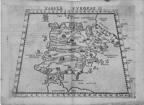
Tabula Europae II


Library: Regional Library of Madrid
Uniform Title: España. Mapas generales. ca. 1574
Title: Tabula Europae II [Material cartográfico]
Área de datos: Escala [ca. 1:8.500.000]. 1 grado de latitud [= 1,3 cm]
Publication: [Venecia : G. Ziletti, 1574?]
Physical description: 1 mapa : grab. ; 18 x 25 cm en h. de 22 x 30 cm
Notes: Referencias: Fuente de información: Hernando, A. El mapa de España, 1995, p. 113-114 y Tooley's dictionary of mapmakers, 1999-2004, v.4, p. 87 y 432
Márgenes graduados. Red hidrográfica. Relieve por montes de perfil y sombreado. Ciudades representadas por conjuntos de edificaciones según su importancia
Datos de publicación tomados del catálogo del librero
Probablemente este mapa se publicó incluido en la "Geographia" de Ptolomeo editada por G. Ruscelli e impresa por G. Ziletti en Venecia, 1564, 1574
Al verso: "D'Europa Tavola Seconda Antica"
Subject / place / event: España - Historia - S.II - Mapas
Portugal - Historia - S.II - Mapas
Other authors: Ruscelli, Girolamo, ca. 1500-1566
Ziletti, Giordano
Secondary titles: Portugal. Mapas generales. ca. 1574
Document type:
 Maps
Maps
Copyright:


![]()
© BPCM 2013-2020