- Español
- English
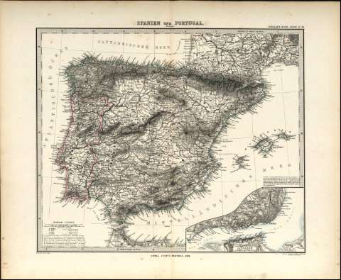
Spanien und Portugal


Library: Regional Library of Madrid
Uniform Title: España. Mapas generales. 1880
Title: Spanien und Portugal [Material cartográfico] / bearbeitet von C. Vogel ; gestochen, situation de schrift v. C. Metzeroth, terrain von W. Weiler
Área de datos: Maafsstab 1:3.700.000. 20 Deutsche oder Geographische Meilen 15=1 Aquatorgrad [=5 cm]
Publication: Gotha : Justus Perthes, 1880
Physical description: 1 mapa : col. ; 31 x 37 cm en h. de 40 x 47 cm
Notes: En ángulo superior izquierdo: Stieler's Hand. Atlas. Nº 38
Escala expresada en otras unidades. Márgenes graduados. Dibujados meridianos y paralelos formando cuadrícula
Relieve representado por normales. Abundante toponimia. Red hidrográfica. Costas sombreadas
Inserta: Mapa de la zona de Lisboa a escala 1:5.000.000
Subject / place / event: España - Mapas
Portugal - Mapas
Other authors: Vogel, Cyrille
Weiler, Wilhelm
Metzeroth, Karl, 1824-1875
Justus Perthes (Firma)
Secondary titles: Portugal. Mapas generales. 1880
Document type:
 Maps
Maps
Copyright:


![]()
© BPCM 2013-2020