- Español
- English
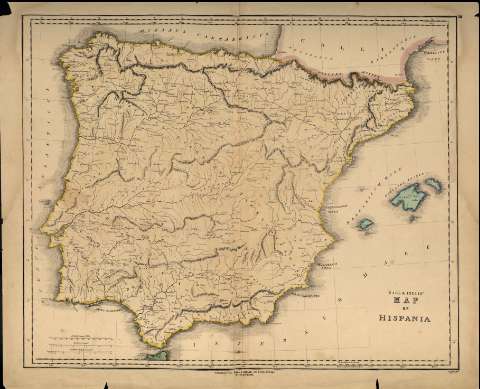
Gall and Inglis' Map of Hispania


Library: Regional Library of Madrid
Uniform Title: España. Mapas generales. ca. 1850
Title: Gall and Inglis' Map of Hispania [Material cartográfico] / B. Smith sculpt
Área de datos: Escala [ca. 1:2.000.000]. 40 Castillian Legal Leagues [=8,2 cm]
Publication: Edinburgh : Gall & Inglis, [1850?]
Physical description: 1 mapa ; 46 x 56 cm en h. de 51 x 61 cm
Notes: En ángulo superior derecho: III
Escala expresada en otras unidades
Márgenes graduados. Red hidrográfica. Costas sombreadas.
Toponimia en latín. Relieve por normales
Subject / place / event: España - Historia - Edad antigua, hasta 414 d.C. - Mapas
Portugal - Historia - Edad antigua, hasta 414 d.C. - Mapas
Other authors: Smith, B.
Gall & Inglis
Secondary titles: Portugal. Mapas generales. ca. 1850
Document type:
 Maps
Maps
Copyright:


![]()
© BPCM 2013-2020