- Español
- English
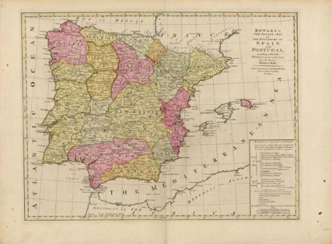
Bowles's New Pocket Map of the Kingdoms of Spain and...


Library: Regional Library of Madrid
Uniform Title: España. Mapas generales. ca. 1778
Title: Bowles's New Pocket Map of the Kingdoms of Spain and Portugal [Material cartográfico] : according to De Lisle; with Improvements on the Coasts from the Charts of Michelot and Bellin
Área de datos: Escala [ca. 1:2.680.000]. Spanish Land Leagues Computed at 17 1/2 to a Degree [= 7,1 cm]
Publication: London : Printed for the Propietor Carington Bowles, Nº 69 in St. Pauls Church Yard, [1778?]
Physical description: 1 mapa : grab., col. ; 46 x 59 cm en h. de 53 x 72 cm
Notes: Título y subtítulo en el ángulo superior derecho junto a otros datos del mapa relacionados con el impresor y el lugar de impresión
Escala expresada también en: 120 Millas estatutarias británicas
Orientado. Puntos cardinales. Márgenes graduados. Dibujados meridianos y paralelos formando cuadrícula. Relieve por montes de perfil y sombreado. Red hidrográfica destacada. Toponimia en inglés con nombres en español y en portugués. Costas sombreadas por un fino rayado. Divisiones administrativas delimitadas por líneas discontinuas para los países y por líneas de puntos para el resto de las divisiones territoriales. Ciudades principales representadas por conjunto de edificaciones
Mapa probablemente perteneciente a la primera edición del Bowles's New Pocket Map of the Kingdoms of Spain and Portugal..." que se publicó entre 1775-1780
Mapa iluminado a la aguada. Divisiones administrativas de España diferenciadas en color amarillo, carmín y verde. Portugal aparece únicamente en color amarillo. Se resaltan los contornos con color. Los contornos de Francia y África levemente destacados con color verde. Las Islas Baleares se distinguen por colores distintos, verde para Mallorca, carmín para Menorca y amarillo para Ibiza
Ámbito geográfico: Abarca también parte del norte de África y sur de Francia
Inserta en el ángulo inferior derecho: "Methodical Division of Spain", cuadro en el que también aparece la división de Portugal en seis provincias. En este cuadro se incluyen, en la parte inferior, las dos escalas
Subject / place / event: España - Mapas
Portugal - Mapas
Other authors: Bowles, Carington, 1724-1793
Secondary titles: Portugal. Mapas generales. ca. 1778
Document type:
 Maps
Maps
Copyright:


![]()
© BPCM 2013-2020