- Español
- English
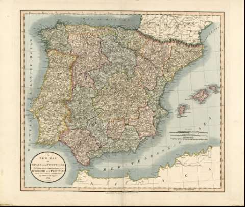
A New Map of Spain and Portugal : divided into their...


Library: Regional Library of Madrid
Uniform Title: España. Mapas generales. 1821
Title: A New Map of Spain and Portugal [Material cartográfico] : divided into their respective Kingdoms and Provinces from the latest authorities / By John Cary, Engraver
Área de datos: Escala [ca. 1:2.422.000]. 140 British Statute Miles 69 1/2 [= 9 ,3 cm]
Publication: London : Published by J. Cary Engraver & Mapseller Nº 181 Strand Jan[uary] 1st, 1821
Physical description: 1 mapa : grab., col. ; 51 x 55 cm en h. de 53 x 62 cm
Notes: Escala expresada también en: "40 Spanish & Portuguese Leagues 18 3/4 to a Degree" y "50 Common French Leagues 25"
Márgenes graduados. Dibujados meridianos y paralelos formando cuadrícula. Meridiano de origen: Greenwich. Relieve por montes de perfil y sombreado . Red hidrográfica y de caminos. Abundante toponimia en inglés con nombres en español y portugués. Divisiones administrativas de los dos países delimitadas por líneas discontinuas, las provincias delimitadas por líneas de puntos. Ciudades representadas por conjuntos de edificaciones según su importancia. Costas sombreadas por un fino rayado
Mapa iluminado a la aguada. Divisiones territoriales en diferentes colores, resaltando las líneas divisorias. La costa africana está perfilada en color amarillo
Cartela circular en el ángulo inferior izquierdo, en la que aparecen datos del título, el autor y el año
Ámbito geográfico: Abarca también parte del norte de África y sur de Francia
Subject / place / event: España - Mapas
Portugal - Mapas
Other authors: Cary, John, 1755-1835
Secondary titles: Portugal. Mapas generales. 1821
Document type:
 Maps
Maps
Copyright:


![]()
© BPCM 2013-2020