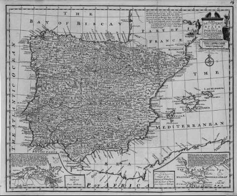
A new & accurate map of Spain and Portugal


Sección: Biblioteca Regional de Madrid
Título uniforme: España. Mapas generales. ca. 1750
Título: A new & accurate map of Spain and Portugal [Material cartográfico] / drawn from Surveys assisted by ye. most approved modern maps and charts ; the whole being regulated by astronomical observations by Eman. Bowen
Área de datos: Escala [ca. 1:3.500.000]. 25 English & French Leagues 20 to a Degree [= 4 cm]
Publicación: [S.l. : s.n., 1750?]
Descripción física: 1 mapa : grab. ; 36 x 43 cm en h. de 38 x 46 cm
Notas: Escala expresada en otras unidades
Márgenes graduados. Orientado con flor de lis
Abundante toponimia en inglés y español. Red hidrográfica. Relieve por montes de perfil y sombreado. Costas sombreadas.
Divisiones administrativas diferenciadas por líneas de puntos
Fecha de publicación tomada del catálogo del librero
Título en cartela arquitectónica, a los lados paisaje y personaje masculino con dos perros
Inserta: en la parte inferior, mapa del puerto de Mahon a escala [ca. 1:88.000] y mapa del estrecho de Gibraltar a escala [ca. 1:2.300.000], ambos con textos explicativos en inglés y en la parte superior derecha, texto en inglés relativo a la confección del mapa
Materia / geográfico / evento: España - Mapas
Portugal - Mapas
Autores secundarios: Bowen, Emanuel, ca. 1693-1767
Títulos secundarios: Portugal. Mapas generales. ca. 1750
Tipo de publicación:
 Mapas
Mapas
Derechos:


![]()
© BPCM 2013-2020