- Español
- English
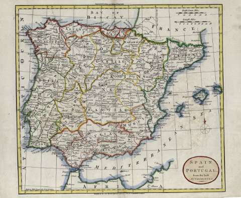
A map of Spain & Portugal Drawn from the Best Authorities


Sección: Biblioteca Regional de Madrid
Título uniforme: España. Mapas generales. Ca. 1785
Título: A map of Spain & Portugal [Material cartográfico] Drawn from the Best Authorities / [C. Paas]
Área de datos: Escala [ca. 4.350.000]. 100 British Statute Miles [=7,2 cm]
Publicación: [London?] : [C. Paas?], [1785?]
Descripción física: 1 mapa : grab. ; 22 x 28 en h. de 23 x 33 cm
Notas: Datos del área de mención de responsabilidad tomados del librero
Orientado con lis en cuadrante. Márgenes graduados. Relieve por montes de perfil y sombreado. Red hidrográfica. Toponimia en inglés con nombres en español y portugués. Curvas batimétricas. Divisiones territoriales delimitadas por líneas de rayas para los países y por líneas de puntos para las provincias
Datos del área de publicación tomados del librero
Ámbito geográfico: Abarca también Portugal y parte de la costa norte de África
Materia / geográfico / evento: España - Mapas
Portugal - Mapas
Autores secundarios: Paas, Cornelis, . fl. 1785-1815
Títulos secundarios: Portugal. Mapas generales. Ca. 1785
Tipo de publicación:
 Mapas
Mapas
Derechos:


![]()
© BPCM 2013-2020