- Español
- English
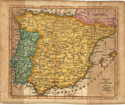
Spain and Portugal


Library: Regional Library of Madrid
Uniform Title: España. Mapas generales. Ca. 1769
Title: Spain and Portugal [Material cartográfico] / Drawn from the latest Authorities, By Tho[ma]s Kitchin Geo[graphe]r
Área de datos: Escala [ca. 1:5029188]. 100 British Statute Miles [=3,2 cm].
Publication: [London?] : [s.n.], [1769?]
Physical description: 1 mapa : grab., col. ; 18 x 23 cm en h. de 22 x 27 cm
Notes: Título en el ángulo inferior derecho
Mapa probablemente perteneciente a: "Pocket Atlas" de Tomas Kitchin, 1769
Orientado con rosa de los vientos de 8 rumbos con lis en la parte derecha. Márgenes graduados. Dibujados meridianos y paralelos formando cuadrícula . En la parte inferior se dan las longitudes referidas al meridiano de Londres y la longitud oriental. Relieve por montes de perfil y sombreado. Red hidrográfica. Toponimia en inglés con nombres en español y portugués. Divisiones administrativas delimitadas por líneas discontinuas de rayas para países y de puntos para las provincias
Datos del área de publicación tomados de la obra anteriormente citada
Divisiones administrativas de España, Portugal y Francia iluminadas a la aguada en color naranja para España, en color verde, para Portugal y en color rosa para Francia. Las divisiones territoriales del interior de España aparecen resaltadas por líneas de color naranja y las de Portugal por líneas de color verde
Subject / place / event: España - Mapas
Portugal - Mapas
Other authors: Kitchin, Thomas, 1719-1784
Secondary titles: Portugal. Mapas generales. Ca. 1769
Document type:
 Maps
Maps
Copyright:


![]()
© BPCM 2013-2020