- Español
- English
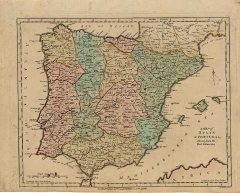
A map of Spain and Portugal Drawn from the best authorities


Sección: Biblioteca Regional de Madrid
Título uniforme: España. Mapas generales. 1794
Título: A map of Spain and Portugal [Material cartográfico] Drawn from the best authorities / T. Conder sculp.
Área de datos: Escala [ca. 1:4.600.000]. 150 British Statute Miles [=5 cm]
Publicación: London : published Janry 1st. 1791 by R. Wilkinson, Nº 58, Cornhill, 1794
Descripción física: 1 mapa : grab., col. ; 23 x 30 cm en h. de 26 x 33 cm
Notas: Título en el ángulo inferior derecho
Orientado con rosa de los vientos con lis. Márgenes graduados. Meridiano de origen: London. Relieve por montes de perfil y sombreado. Red hidrográfica. Toponimia en inglés con nombres en español y portugués. Costas sombreadas
Mapa iluminado a la aguada. Divisiones administrativas diferenciadas por color iluminadas a la aguada. Líneas divisorias resaltadas en color amarillo y rojo
Ámbito geográfico: Abarca también parte de la costa del norte de África
Materia / geográfico / evento: España - Mapas
Portugal - Mapas
Autores secundarios: Conder, Thomas, fl. 1755-1801
Wilkinson, Robert, m. ca. 1825
Títulos secundarios: Portugal. Mapas generales. 1794
Tipo de publicación:
 Mapas
Mapas
Derechos:


![]()
© BPCM 2013-2020