- Español
- English
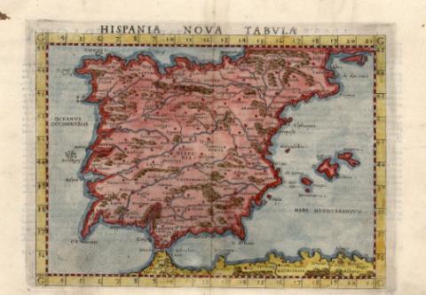
Hispania Nova Tabvla


Library: Regional Library of Madrid
Uniform Title: España. Mapas generales. ca. 1574
Title: Hispania Nova Tabvla [Material cartográfico] / [Claudius Ptolemaeus]
Área de datos: Escala indeterminada
Publication: [In Venetia?] : [apresso Giordano Ziletti?], [1574?]
Physical description: 1 mapa : grab., col. ; 19 x 26 cm en h. de 22 x 31 cm
Notes: Título en la parte central superior de la hoja, encima del mapa
Mapa probablemente perteneciente a: "La Geografía" de Claudio Ptolomeo y editada por Ziletti, en Venecia en 1574, según consta en el catálogo en línea de la Bibliotheks Verbund Bayern
Márgenes graduados, indicada la letra G de grado en los cuatro ángulos de los márgenes. Relieve por montes de perfil y sombreado. Red hidrográfica. Toponimia escasa en latín. Ciudades representadas por círculos según su importancia
Datos del área de publicación tomados de la obra anteriormente citada
Mapa iluminado a la aguada en color rosa para el mapa, marrón para los montes, azul para la hidrografía y amarillo para la costa africana
Ámbito geográfico: Comprende toda la Península Ibérica
Incluye al verso del mapa: "Della Spagna Secunda Tavola Nuova D'Europa". Inicial del texto grabada e iluminada. Texto explicativo en italiano
Subject / place / event: España - Mapas
Portugal - Mapas
Other authors: Ptolomeo, Claudio
Ziletti, Giordano
Secondary titles: Portugal. Mapas generales. ca. 1574
Document type:
 Maps
Maps
Copyright:


![]()
© BPCM 2013-2020